Mount Kailash (6,638 m / 21,778 ft) is Asia’s holiest mountain. Located in the far reaches of western Tibet, for centuries it has been an important pilgrimage site for Hindus, Buddhists, and members of the Bon and Jain faiths. Many pilgrims journey to this remote Himalayan corner with the goal of completing a Kora, which is Tibetan for the circumambulation of a holy place. According to Buddhists, one circuit around Mount Kailash will absolve the sins of a lifetime, and for those looking for a little more in the way of karmic insurance, it is said that 108 circuits will lead to nirvana and freedom from reincarnation. Because of its sacred qualities, the mountain has never been summited.
I hiked the Kailash Kora in the spring of 2006, as part of a two-month journey around Tibet. To this day it remains one of my most memorable hiking experiences. All logistical details have been updated as of April 2020.
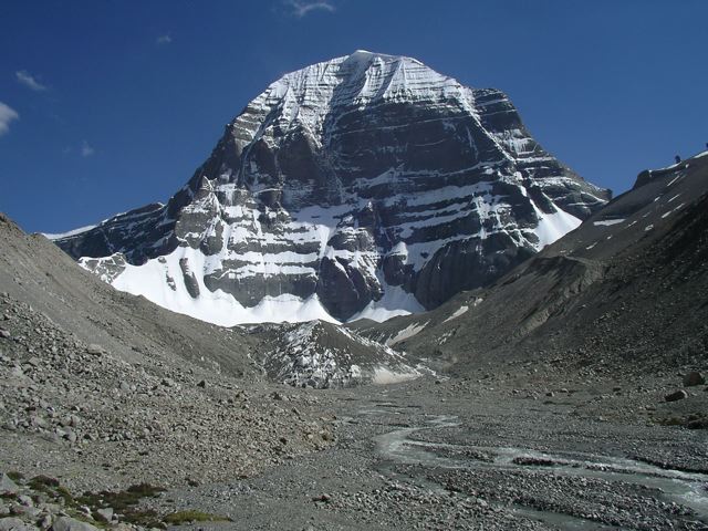
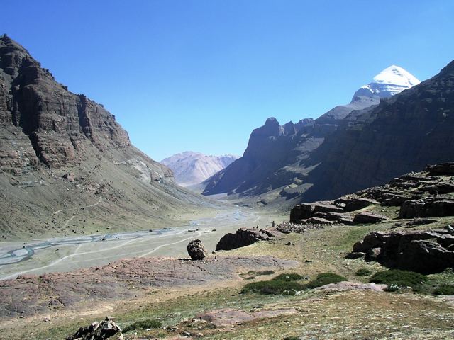
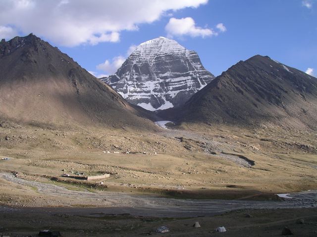
Nearing the base of Kailash’s northern face, on a side trip from Drira Phug monastery.
At a Glance
Distance: 32.3 miles (52 km)
Average Time: 3 days
Start / Finish: Darchen
Difficulty: Moderate to challenging
Highest Point: 5,630 m (18,471 ft) – Drolma La Pass.
Lowest Point: 4,675 m (15,338 ft) – Darchen
Season: May – October. During trekking season, daytime temperatures are usually in the low to high teens (celsius), with nighttime temperatures often dropping below freezing. Snow is possible at any time of year.

Pilgrims on the Mount Kailash kora.
Maps & Information
- Logistics: During my visit in 2006 it was still possible (though by no means easy) to travel around Tibet independently, thus all of my hikes in the Himalayan nation were solo affairs. Unfortunately, things changed in 2008, and since that time it is no longer possible to travel independently in Tibet. Therefore to hike around Mount Kailash you must now go through a Tibetan travel agency, which will organize permits, a private vehicle with a driver to get you to the mountain (see Getting There & Away), and a tour guide. Note that most organized groups consist of three to four travelers, however, if you have the money, it is also possible to organize a private tour. Also keep in mind that travel permits for Mount Kailash can take up to a month to process, so be sure to book well in advance. For a comprehensive overview of the ins and outs of traveling in Tibet in 2021, see this excellent guide by the folks at YoWangdu Experience Tibet.

Mount Kailash Kora Overview Map (From Tibet Vista / Tibettravel.org – a Lhasa-based agency that has been organizing trips for tourists since 1984).
- Getting There & Away: Trips to Kailash are normally part of a two to three-week jeep tour around central and western Tibet. Other highlights of such a trip include a visit to Everest Base Camp, remote monasteries, and the sacred lakes of Manasarovar and Yamtrok. These 4WD journeys generally don’t include much trekking outside of the Kailash Kora, however, it may be possible to organise additional multi-day hikes with your chosen agency, including a kora around Lake Manasarovar and a trek from the village of Tingri to Everest Base Camp (Tibetan side).
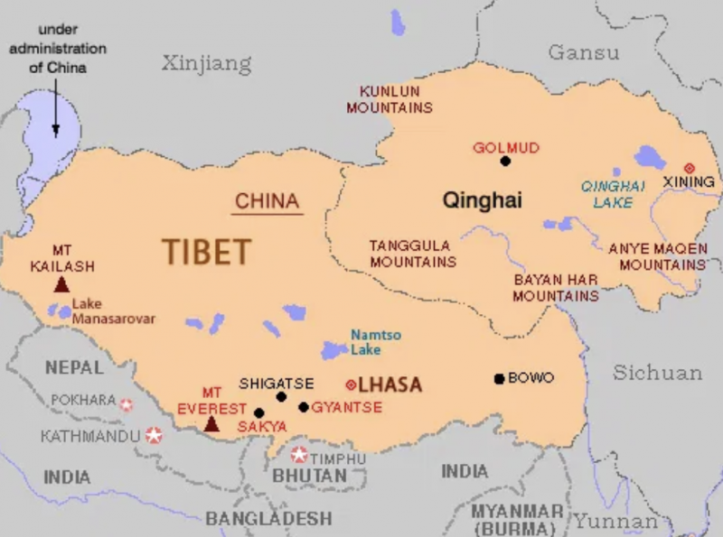
Tibet Overview map | Mount Kailash can be seen on the far left, just north of the Nepalese border.
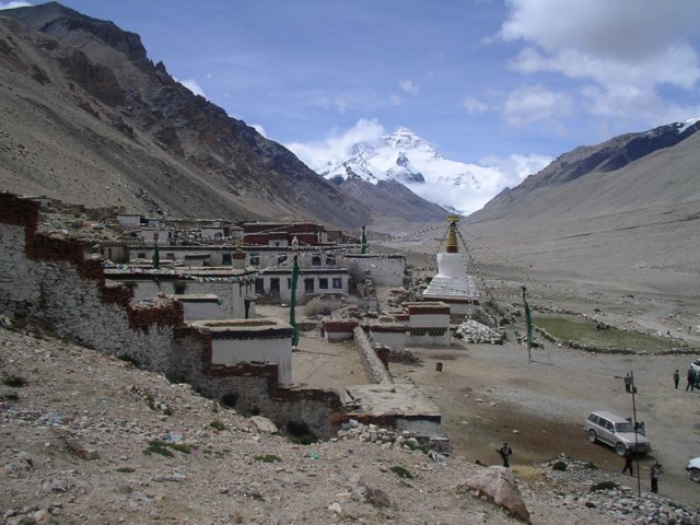
One of the highlights of the Tingri to Everest Base Camp trek is Rongphu Monastery. Located at 4920m above sea level, Rongphu is reputedly the world’s highest monastery. The tall snow-capped mountain in the background is Mount Everest.
- Guidebooks: I used the trekking notes and basic maps contained in Gary McCue’s Trekking in Tibet (now in its 3rd edition) and Lonely Planet’s Tibet guide. Both books provide an overview of Mount Kailash’s geographic, cultural and spiritual significance. McCue’s excellent guide has been the go-to source for hiking trips in Tibet since the 1990s. Another option (which I haven’t personally seen) is Cicerone Press’, Mount Kailash Trek: A Trekker’s and Visitor’s Guide (2007).
- Online Information: See Lonely Planet’s website for detailed trekking notes for the Kailash kora. See their Thorn Tree Forum for up-to-date information on traveling in Tibet.
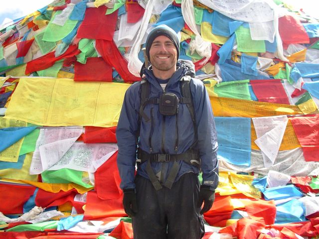
Yours truly among a sea of prayer flags on Drolma La Pass, the highest point of the Mount Kailash Kora (5,630 m / 18,471 ft).
- Saga Dawa Festival: During my visit to Kailash in 2006, I experienced Saga Dawa, which is one of Tibet’s most important religious festivals. It is celebrated annually on the full moon day of the fourth Tibetan Lunar month (in either May or June), in honour of the birth, enlightenment, and death of Buddha. Many pilgrims time their visit to Kailash to coincide with the Saga Dawa celebrations, the highlight of which is the raising of the Tarboche Flagpole. Each year the old pole is replaced by a new one, and how straight the pole stands once it is erected is said to be a harbinger of the country’s fortunes for the coming year. Completely vertical is ideal; leaning too much to either side is not so great.
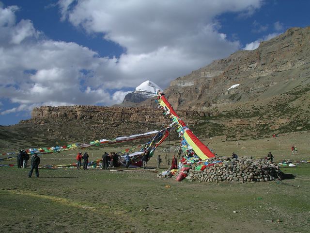
The Tarboche flag pole with Kailash’s snow-capped dome in the background.
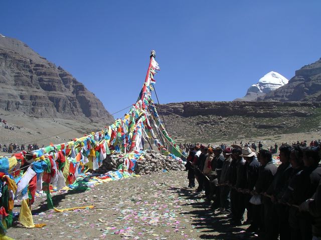
Raising the Tarboche flag pole during Saga Dawa.
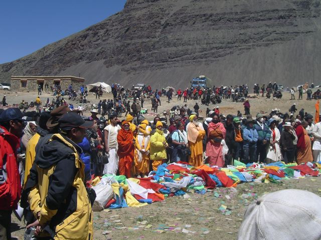
Rugged-up pilgrims watching the Saga Dawa ceremony.
Five Facts about Mount Kailash
1. Mount Kailash lies near the source of four of Asia’s greatest rivers – Indus, Sutlej, Brahmaputra, and Karnali.
2. According to Hindus, Kailash is the “pillar of the world”, and on its snow-capped summit resides Lord Shiva, the third God of their Holy Trinity.
3. Buddhists also believe that Kailash is the spiritual center of the universe, as well as being the home of Buddha Demchok, who symbolizes supreme bliss.
4. To this day, Mount Kailash has never been climbed. In the mid-1980s the Chinese government offered legendary mountaineer Reinhold Messner permission to climb Mount Kailash. He declined the invitation. In the early 2000s, a Spanish team of climbers obtained permission from the Chinese government to scale the holy peak, however, due to the overwhelmingly negative international reaction, the offer was rescinded. Since this time the Chinese authorities have banned any future attempts.
5. Located approximately 40 km (25 mi) south of Mount Kailash is Lake Manasarovar. At 4,590 m (15,060 ft) above sea level, Manasarovar is one of the highest freshwater lakes in the world. Considered to be the holiest of Tibetan lakes, it is venerated by Hindus and Buddhists alike, and for more than two thousand years pilgrims have traveled here to complete a Kora around its shores. In 2006 I completed a 110 km (68.4 mi) circumambulation of the lake immediately after finishing my trek around Kailash.
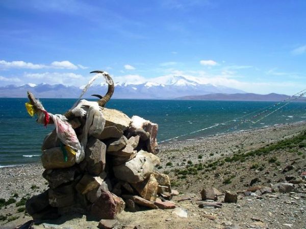
Views from the Lake Manasarovar Kora.
Route / Conditions
- Which Direction? Buddhist and Hindu pilgrims walk the kora in a clockwise direction. Adherents of the ancient Bon (which preceded Buddhism in Tibet) and Jain faiths, walk in a counter-clockwise direction.
- How Much Time Will I Need? Tibetans traditionally do the hike in one very long day, while foreigners usually take a more sedate three days. Some devout aspirants even choose to circumnavigate Kailash doing full-body prostrations, an arduous journey that can take up to two weeks or more!
- Navigationally speaking, the Kailash kora is not difficult. The path is very well worn, you almost always have the mountain in sight, and you’ll invariably be sharing the trail with other pilgrims.
- Provisions and Water: You can either purchase supplies in Darchen before setting out, or pick up food along the way at the monastery guesthouses or large tent camps. Bottled water is also available at these places. If you choose to obtain H20 from rivers and streams, it’s recommended to filter due to the prevalence of donkeys and yaks in the area.
For most of the trek, Kailash’s permanently snowcapped dome is visible to pilgrims.
Heading south from Drolma La Pass on the Kailash kora’s well-worn path.
- Acclimatization: Although route finding is a non-issue on the Kora, any trail that goes up and over an often-snowbound 5,630 m (18,471 ft) pass will never be considered easy. Before attempting a trek around Kailash, hikers should be well prepared in regards to fitness, equipment, and acclimatization. In regard to the latter, see Tips for Hiking at High Altitude.
Approaching Drolma La Pass (5630 m / 18,471 ft).
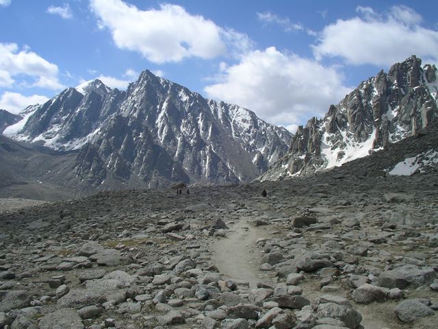
Tuoji Lake (5568 m / 18,268 ft).
- Recommended Side Trip: Kailash’s snowcapped dome and diamond-like shape is a stirring sight to behold, and hikers are treated to outstanding views of the peak throughout much of the trail. One of the best vantage points of the mountain is on a highly recommended side trip to Gangjam Chu valley. Beginning from Drira Phug monastery, this strenuous out-and-back excursion takes between three and four hours to complete and affords the opportunity to get up close and personal with Gangjam glacier and Kailash’s sheer north face.
Gazing at the Gangjam Chu valley and Kailash’s dramatic north face from the Dirapuk monastery.
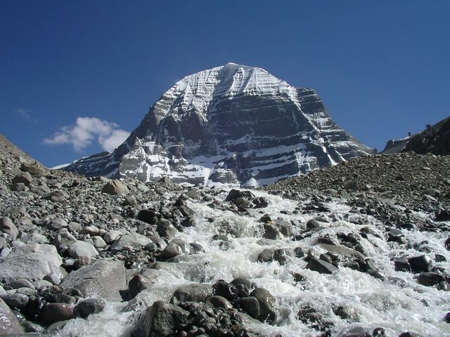
Stream emanating from Gangjam glacier on Kailash’s north face.
Accommodation
- You can procure accommodation at either the monastery guesthouses, the Shishapangma Hotel (Xixapangma Hotel), or large tent camps that are erected close to the monasteries during pilgrimage season. If sleeping with a bunch of snoring wayfarers in a confined space isn’t your cup of yak butter tea, I highly recommend bringing along your own shelter. Campsite opportunities abound throughout the kora.
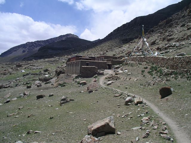
Dzultripuk Monastery (4,835 m / 15,863 ft).
Final Thoughts
The Pilgrims Bond
Mount Kailash brings together people of different beliefs, cultures, and origins. A melting pot of humanity connected through the ancient bond of pilgrimage. And therein lies a fundamental part of Kailash’s significance; the sense of camaraderie it inspires among pilgrims. This remote mountain in the west of Tibet is a beacon of shared faith, and a walk around its circumference represents the realization of many collective goals and dreams. Speaking of which………..
Three Tibetans and an Australian
I started my kora around Kailash quite late in the day in order to catch the Saga Dawa ceremonies. That night I camped not far from Dirapuk monastery, after doing a worthwhile side trip to Kailash’s north face (see above). The following morning I was up before dawn, and not long after hitting the trail I caught up to a trio of jovial Tibetan pilgrims. I greeted them with an enthusiastic “tashi deleg” (hello in Tibetan), and as they looked around they were more than a little surprised to see a solo foreigner, carrying all of his own gear, who was clipping along at a pace which was more or less similar to their own. They gave me a huge collective smile, and the member of the trio that spoke a tiny bit of English, pointed at me then slapped his legs and said, “strong, strong, strong.” I gave them a wink and an equally big grin in return, slapped my own legs, and replied, “ray, ray, ray” (“yes, yes, yes” in Tibetan) which made them chuckle even more. They motioned for me to join them, which I happily did. For the next few hours my new-found companions and I hiked together, shared Yak Butter Tea, and did an inordinate amount of joking and laughing considering the limitations of my abilities in the local language.
The photo below is of the four of us on top of Drolma La Pass, and it remains one of my favourite images from my time in Tibet. Not only does it encapsulate the pilgrim’s bond I mention above, but it also confirms something that I’ve found to be true on almost all my travels over the decades; that is, a good sense of humour and an open spirit go a long way in transcending language and cultural obstacles. In the case of Tibet, the ability to drink multiple yak butter teas at a sitting – no small libational feat – doesn’t hurt either.
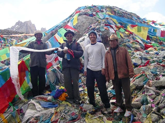
Drolma La Pass, Mount Kailash Kora, 2006.
*Disclosure: This post contains some affiliate links, which means The Hiking Life receives a small commission if you purchase an item after clicking on one of the links. This comes at no additional cost to the reader and helps to support the website in its continuing goal to create quality content for backpackers and hikers. Cheers.
Related Posts
- Lake Manasarovar Kora
- Tingri to Everest Base Camp
- Ganden Monastery to Samye Monastery
- Cultural Considerations when Hiking Abroad
- Gear List: Trekking in the Himalaya (coming soon…….ish)
Discover more from The Hiking Life
Subscribe to get the latest posts to your email.
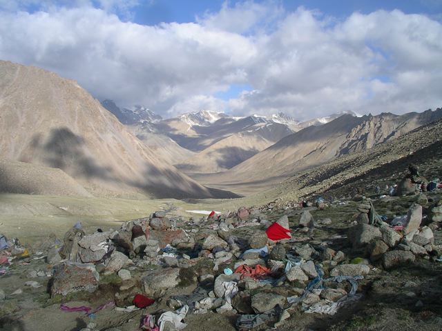
Is there any feelings of concern about all the prayer flags on the ground posing an environmental problem? Does someone come along and clean them up?
That photo and the other image of yours truly were both taken on Drolma La Pass. There is an incredible amount of prayer flags on that high point (perhaps more than on any other Himalayan pass I have visited)- both suspended and on the ground. I can’t say for certain, but my guess would be that at the end of each trekking season the local authorities do a clean-up, otherwise, there would be a pile of flags 50 ft high!