Jambudvipa – India or Ancient Bharata
Puranic description as per Hindu cosmology
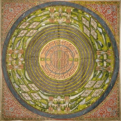
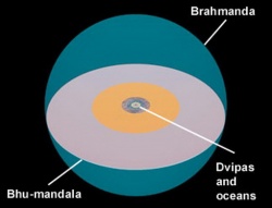
According to Puranic cosmography, the earth is divided into seven concentric island continents (sapta-dvipa vasumati) separated by the seven encircling oceans, each double the size of the preceding one. The seven continents of the Puranas are stated as Jambudvipa, Plaksadvipa, Salmalidvipa, Kushadvipa, Krounchadvipa, Shakdvipa, and Pushkaradvipa. Seven intermediate oceans consist of salt-water, sugarcane juice, wine, ghee, curd, milk and water respectively.[1],[2]
Continent Jambudvipa (Indian Blackberry Island), also known as Sudarshanadvipa, forms the innermost concentric island in the above scheme. Its name is said to derive from a Jambu tree (another name for the Indian Blackberry, a kind of black plum). The fruits of the Jambu tree are said to be as large as elephants and when they become rotten and fall upon the crest of the mountains, a river of juice is formed from their expressed juice. The river so formed is called Jambunadi (Jambu river) and flows through Jambudvipa, whose inhabitants drink its waters. Insular continent Jambudvipa is said to comprise nine varsas (zones) and eight significant mountains.
Markandeya Purana portrays Jambudvipa as being depressed on its south and north and elevated and broad in the middle. The elevated region forms the varsa named Ila-vrta or Meruvarsa. At the center of Ila-vrta lies the golden Mount Meru, the king of mountains and the support of the planet earth. On the summit of Mount Meru is the vast city of Lord Brahma, known as Brahmapuri. Surrounding Brahmapuri are the cities of Lord Indra and of seven other devatas or demigods.
The varsas of Ramyaka (or Ramanaka), Hiranmaya (or Hiranyaka) and Uttarakuru (or Shringashaka) are said to lie on the north, those of Hari, Kimpurusha and Bharata on the south and of Ketumala and Bhadrasva on the west and east sides of Mount Meru respectively.
The mountains named Nishada, Hemakuta and Himavan (Himalaya) lie on the south, mountains Nila, Sveta and Sringavan on the north, those of Malayavat and Gandhamadana on the west and east direction of Mount Meru respectively.
The geographical description of the Jambudvipa is given in great detail in Bhishmaparva of the Mahabharata and several Puranas.
Markandeya Purana and Brahmanda Purana divide Jambudvipa into four vast regions shaped like four petals of a lotus with Mount Meru being located at the center like a pericarp. The city of Brahmapuri is said to be enclosed by the river Ganga, known as Akash Ganga. River Ganga is said to issue forth from the foot of Lord Vishnu and after washing the lunar region falls “through the skies” and after encircling the Brahmapuri “splits up into four mighty streams”, which are said to flow in four opposite directions from the landscape of Mount Meru and irrigate the vast lands of Jambudvipa. River Sita irrigates the Bhadrasva varsa, river Jambunadi streams through the Ketumala varsa, river Alakananda flows through the Bharata varsa and river Bhadra washes the lands of the Uttara-Kuru varsa.[3]
Real-world identification
So far there is no satisfactory identification of all zones (varsas) of Jambudvipa. The Vayu Purana furnishes some details of the mountain ranges, valleys and river systems of the geographical region of Jambudvipa making it possible to identify some of their geographical features.
Mount Meru (or Sumeru) is identified with the vast Nagard Sarovar in the center of the modern Pamir mountain range.
The Padma Purana identifies the river Jambunadi with the river Chaksu (Amu Darya).[4]
The river Alakananda or Akash Ganga is the Ganges river.
The river Bhadra corresponds to the Jaxartes or Syr Darya.
The river Sita (Sito of Hiuen Tsiang) corresponds to the Yarkand River.
Bhadrasva varsa probably corresponds to the major part of Xinjiang province of China and the region lying to its east.
Uttara-Kuru varsa is the region to the north of the Pamirs. It probably includes the north-western parts of Xinjiang province of China, the Tien Shan region, and most parts of Kyrgyzstan.
Ketumala varsa is said to be the region spanned by the Amu Darya, and therefore may correspond to western Turkmenistan, north-west Afghanistan (ancient Bactria) and north-east Iran.
Hari varsa is probably represented by western Tibet.
Bharata varsa undoubtedly stands for the whole undivided India.
Ila-Vrta varsa (Meruvarsa) is the mountainous region around the central point of Meru. It probably includes the Pamirs, Badakshan, parts of Kashmir, North-West Frontier region and north-east Afghanistan, etc.
Other varsas of Jambudvipa has not been identified.
As regards the Dvipas or insular continents:
The Shakadvipa (the vast Scythe region) was identified by some as north Turkmenistan, Uzbekistan and Kazakhstan and some regions to north and west of the Caspian Sea.
The author of Vayu Purana uses the name Kumuda-dvipa for Kusha-dvipa.[5] Kumuda is also a Puranic name of a mountain forming the northern buttress of Mount Meru (i.e. Pamirs). In anterior Epic Age Kumuda was the name given to high table-land of the Tartary located to north of the Himalaya range. Thus, the Kumuda-dvipa lay close to the Pamirs. Some scholars connect this Kumuda (the Komdei of Ptolemy, probably Kamdesh from Kamboj-desh?) with ancient Iranian Kambojas.
The river Kurumu (modern Kuram) on south of river Kubha (Kabol) is stated to be flowing through the Plaksa-dvipa of the Puranic accounts. Hence the Plaksa-dvipa may have been the region lying to west of the Indus River probably comprising territories of Iran, middle and southern Afghanistan and parts of Pakistan, etc.
The Pushkaradvipa has been identified by some as the region lying between China and Mangala (perhaps China and Mongolia) based on the evidence of medieval era Muslim scholar Al-Biruni.
There has been an attempt to plot the concentric continents on solar system.[6] Their identification is difficult since, according to Matsya Purana, they are of super-human nature.
The common names of the dviipa-s, having their vars.a-s (9 for Jambu-dviipa, 7 for the other dviipa-s) with a mountain and a river in each vars.a, is given in several Puraan.a-s [1]. There is a distinct set of names provides, however, in other Puraan.a-s [2]. The most detailed geography is that described in the Vaayu Puraan.a [3].
In Buddhism
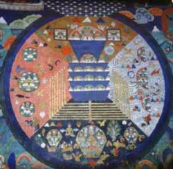
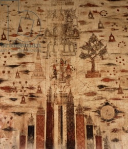
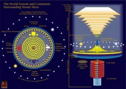
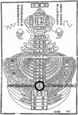
The Buddhist cosmology divides the bhūmaṇḍala (circle of the earth) into three separate levels: Kāmadhātu (Desire realm), Rūpadhātu (Form realm), and Ārūpyadhātu (Formless realm). In the Kāmadhātu is located Mount Sumeru which is said to be surrounded by four island-continents. “The southernmost island is called Jambudvīpa”. The other three continents of Buddhist accounts around Sumeru are not accessible to humans from Jambudvīpa. Jambudvīpa is shaped like a triangle with a blunted point facing south. In its center is a gigantic Jambu tree (rose-apple) from which the continent takes its name, meaning “Jambu Island”.
Jambudvīpa is the region where the humans live and is the only place where a being may become enlightened by being born as a human being. It is in Jambudvīpa that one may receive the gift of Dharma and come to understand the Four Noble Truths, the Noble Eightfold Path and ultimately realize the liberation from the cycle of life and death.
Another reference is from the Buddhist text Mahavamsa, where the emperor Ashoka‘s son Mahinda introduces himself to the Sri Lankan kind Devanampiyatissa as from Jambudvipa, referring to what is now the Indian mainland.
[edit] In Jainism
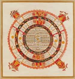
According to Jain cosmology, Jambūdvīpa (The island of the rose apple tree) is at the centre of Madhyaloka, or the middle part of the universe, where the humans reside. Jambūdvīpaprajñapti or the treatise on the island of Roseapple tree contains a description of Jambūdvīpa and life biographies of Ṛṣabha and King Bharata. Trilokasāra (Essence of the three worlds), Trilokaprajñapti (Treatise on the three worlds), Trilokadipikā (Illumination of the three worlds) and Kṣetrasamasa (Summary of Jain geography) are the other texts that provide the details of Jambūdvīpa and Jain cosmology. Madhyaloka consists of many continent-islands surrounded by oceans, first eight whose names are :-
Continent/ Island Ocean
Jambūdvīpa Lavanoda (Salt – ocean)
Ghatki Khand Kaloda (Black sea)
Puskarvardvīpa Puskaroda (Lotus Ocean)
Varunvardvīpa Varunoda (Varun Ocean)
Kshirvardvīpa Kshiroda (Ocean of milk)
Ghrutvardvīpa Ghrutoda (Butter milk ocean)
Ikshuvardvīpa Iksuvaroda (Sugar Ocean)
Nandishwardvīpa Nandishwaroda
Mount Meru is at the centre of the world surrounded by Jambūdvīpa, in form of a circle forming a diameter of 100,000 yojans [7].
Jambūdvīpa continent has 6 mighty mountains, dividing the continent into 7 zones (Ksetra). The names of these zones are:
Bharat Kshetra
Mahavideh Kshetra
Airavat Kshetra
Ramyak
Hairanyvat Kshetra
Haimava Kshetra
Hari Kshetra
The three zones i.e. Bharat Kshetra, Mahavideh Kshetra and Airavat Kshetra are also known as Karma bhoomi because practice of austerities and liberation is possible and the Tirthankaras preach the Jain doctrine. The other four zones, Ramyak, Hairanyvat Kshetra, Haimava Kshetra and Hari Kshetra are known as akarmabhoomi or bhogbhumi as humans live a sinless life of pleasure and no religion or liberation is possible.
